The official version of this document can be found via the PDF button.
The below content has been automatically generated from the original PDF and some formatting may have been lost, therefore it should not be relied upon to extract citations or propose amendments.
Scrutiny Review
Draft Water Resources (Jersey) Law
Technical Assessment of Evidence Presented
30 June 2004 Entec UK Limited
Report for
States of Jersey Scrutiny Office, States Building, Royal Square,
![]() St. Hellier, JE1 1BA
St. Hellier, JE1 1BA
Main Contributors Stuart Sutton
Scrutiny Review
Draft Water Resources (Jersey) Law
Technical Assessment of Evidence Presented
![]() Issued by 30 June 2004
Issued by 30 June 2004 ![]() Entec UK Limited
Entec UK Limited
![]() Stuart Sutton Approved by
Stuart Sutton Approved by
![]()
![]() Stuart Sutton Entec UK Limited
Stuart Sutton Entec UK Limited
160-162 Abbey Foregate Shrewsbury
Shropshire
SY2 6BZ
England
Tel: +44 (0) 1743 342000 Fax: +44 (0) 1743 342010
h:\projects\hm-250\13668 jersey\docs\rr015i1.doc


Certificate No. EMS 69090 Certificate No. FS 13881
In accordance with an environmentally responsible approach, this document is printed on recycled paper produced from 100% post-consumer waste, or on ECF (elemental chlorine free) paper
![]() Executive Summary
Executive Summary
The written technical evidence provided to the Scrutiny Committee in connection with the Draft Water Resources (Jersey) Law is principally:
- A view of the state of the groundwater resources of Jersey developed over 14 years of investigation and monitoring by the British Geological Survey (BGS);
- Disagreements with the BGS view presented by the Water Diviners and Engineers Association (WDEA).
The BGS concept of the groundwater system is of a relatively "shallow" aquifer supported by rainfall recharge. The WDEA claim that there is also a deep groundwater resource supported by recharge on the French mainland.
Up to about 1996 the BGS view of the state of the groundwater resource was of a resource under extreme stress with annual abstraction and baseflow requirements almost equal to recharge. Revision of infiltration (recharge) estimates based on the Trinity Catchment Study (1996) suggest that abstraction and baseflow are equivalent to about 50% of average annual recharge. Water level and chemical monitoring data show no indication of long term decline in levels or deterioration of chemical qualityThese records do not cover prolonged periods of below average rainfall. Estimates of annual abstraction totals are poorly constrained.
WDEA provide evidence of deeper groundwater resources additional to those of the shallow aquifer but the resource is not quantified.
The BGS evidence suggests that the groundwater resources of Jersey, as they envisage them, are not deteriorating. If additional resources occur the risk of deterioration is further reduced. In the present context a key reason for abstraction licensing and regulation is to provide a reliable means of calculating total annual abstraction.
![]() Technical discussion of questions of resource origins and quantity estimates is not proposed for the Scrutiny Hearings. Rather a series of questions to investigate whether or not the proposed law is appropriate as a means of abstraction measurement and whether or not a technically robust and defensible means of application determination has been defined, is suggested.
Technical discussion of questions of resource origins and quantity estimates is not proposed for the Scrutiny Hearings. Rather a series of questions to investigate whether or not the proposed law is appropriate as a means of abstraction measurement and whether or not a technically robust and defensible means of application determination has been defined, is suggested.
![]() Contents
Contents
- Data Collection 3
- Conceptual Understanding 3
- BGS Groundwater Balance and Resource Assessment 4
- Man-made Contribution to Groundwater Recharge. 6
- Rainfall and Groundwater Levels 7
- Groundwater Chemistry 7
Table 2.1 BGS Water Balance Components 5
Figure 2.1a GeologicalStructure of Jersey After Page 8 Figure 2.1b Drift Deposits of Jersey After Page 8 Figure 2.2 BGS Conceptual Understanding of Jersey Groundwater After Page 8
Appendix A Borehole Hydrographs and Nitrate Trends [Reproduced from Jersey Groundwater 2002
(BGS Report CR/03/102N)]![]()
This Report has been prepared as a technical assessment of the written evidence presented to the Shadow Scrutiny Panel established for the Scrutiny Review of the Draft Water Resources (Jersey) Law. The assessment was commissioned by the States of Jersey, Scrutiny Office. The purpose of this assessment is to provide a technical synthesis to support questions that may be raised during the Scrutiny Hearings The bulk of the technical information submitted to the Scrutiny Panel is contained in a series of water resource reports prepared by the British Geological Survey (BGS), over the period 1989-2002. These consist of a series of annual reports on the groundwater resources of Jersey for the years 1991-2003 with key summary reports as follows: • 1991 - Hydrogeological and Hydrochemical Survey of Jersey (WF/91/15); • 1992 - Hydrogeological Map of Jersey; • 1996 - Groundwater Resources Degradation in Jersey; Socioeconomic Impacts and their Mitigation (WD/96/8)); • 1998 - The Jersey Groundwater Study (RR/98/5). The data collection and analysis presented in these reports was initiated in 1989 by the report Groundwater Resources of Jersey, A Review with Recommendations for Further Study (BGS Report WD/89/27). Earlier concern for the water resources of Jersey is summarised in the Guthrie Report of 1977 (Jersey's Water - A New Appraisal) prepared in the aftermath of the 1976 drought. Throughout the BGS work many of the opinions and some of the data has been consistently queried by the Water Diviners and Engineer's Association of Jersey (WDEA) who have presented their views in writing and have commissioned external reviews of the BGS reports. This report is arranged such that a summary of the data and opinions of the BGS is followed by a summary of the key issues raised by WDEA. Following this, a brief assessment of the possible impact of climate change on water resources is also given. The report finishes with a number of questions which the Scrutiny Panel may wish to address through the Public Hearings scheduled for July 19 and 26, 2004. |
The key data sets which are supplemented by the BGS water resources surveys are: • 1:25 000 Geological Map of Jersey. (Institute of Geological Science, 1982) and the accompanying geological description by Bishop and Bisson published by BGS in 1989; • Meteorological Data as collected by the Meteorological Department of Jersey; • The published geological literature as referenced in the 1991 report. An extensive field survey, including survey of 109 groundwater sources was carried out in 1990. Regular (early summer and winter) monitoring of groundwater chemistry at 50 to 60 sources has continued since 1990 and groundwater levels have been measured monthly at 30 to 40 boreholes and wells since July 1993. Monitoring of abstraction volumes at selected sources (initially 76 in 1989) was discontinued in 1999 because of deterioration of the monitoring network. Monitoring results are presented and assessed in the series of annual Water Resources Reports. In the course of this regular monitoring and surveying BGS have also carried out several key work packages to enhance their understanding of the groundwater resources, notably: • The construction of a groundwater model of the Island of Jersey reported the Year 2 Report (WD/92/22); • The instrumentation and monitoring (weather station, 6 rain gauges, 4 soil moisture sites, continuous stream flow measurement, monitoring of groundwater abstraction and borehole water levels) in the Trinity catchment above Grands Vaux Reservoir for April 1993 - March 1996; • A detailed study of nitrates and nitrogen isotopes to identify pollution sources in 1994 and 1995; • The collection and collation of hydrogeological data from the Fort Regent Cavern Construction in 2000. The results of the Trinity Catchment and Nitrate work packages are integrated and summarised in the 1998 summary report and the Trinity Catchment study in particular has a major impact on resource assessment. Separate reports on these work packages have not, however, been submitted to the Scrutiny Panel. The conceptual model of groundwater in the bedrock of Jersey, proposed and maintained by BGS, is based on the assumption that the ability of the bedrock of Jersey to store (porosity) and |
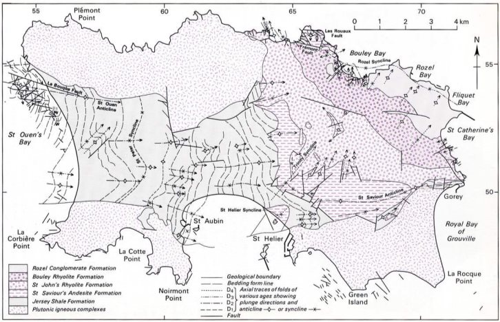
transmit (permeability) groundwater is controlled by fractures and pores induced in the rock mass principally by surface weathering processes. Effectively in the unweathered condition each of the rock types of Jersey (see Figure 2.1a from BGS, 1988) is of very low porosity and permeability.
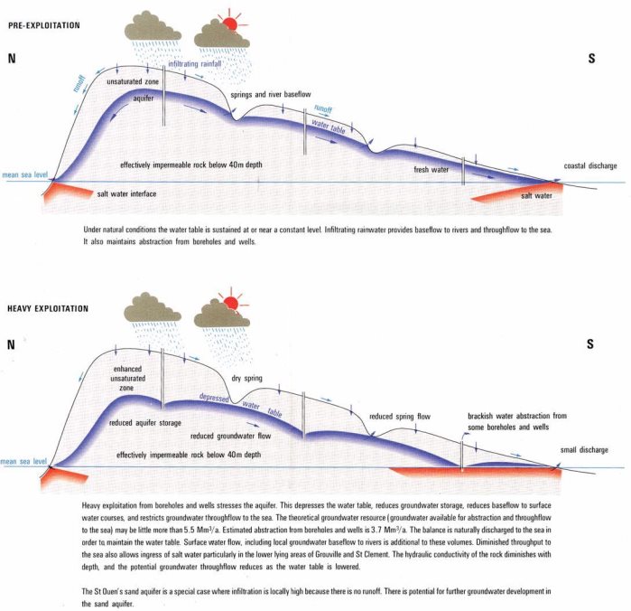
As such the Jersey Bedrock Aquifer is relatively shallow (thin), estimated as extending to depths of 25-40 m bgl. The water table broadly mimics the surface topography at depths generally 10 m or less bgl and the saturated thickness rarely exceeds 25 m (Figure 2.2 from Hydrogeological Map of Jersey).
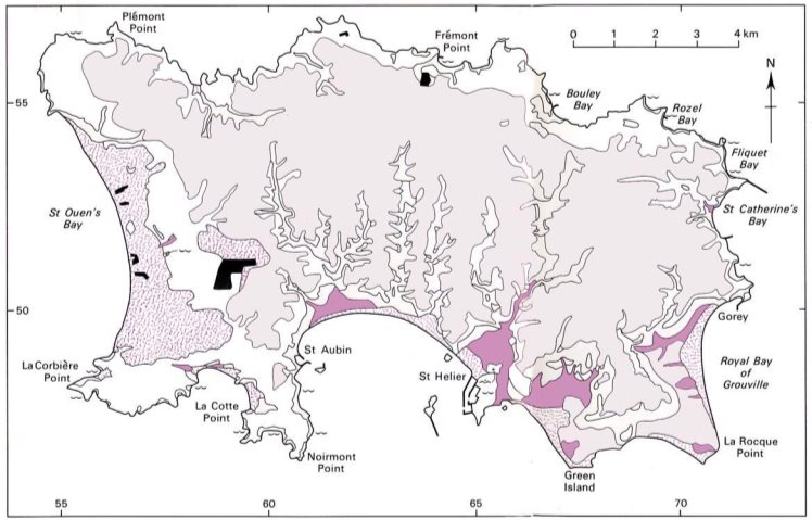
Locally sand deposits as at St.Ouens Bay and to a lesser extent the Royal Bay of Grouville are sufficiently thick and extensive to provide additional groundwater storage above the bedrock. Generally the surface deposits are thin and do not retain significant volumes of groundwater (Figure 2.1b from BGS, 1988).
Water resources within the aquifer are replenished (recharged) principally by infiltration of rainfall through the relatively thin overburden. Recharge will only occur when the soil moisture deficit has been satisfied i.e. generally in the winter months. This annual recharge to the aquifer supports groundwater abstraction and baseflow to the streams and rivers and other wetland habitats (see Figure 2.2). No specific data on the relationship between groundwater and stream bed levels is presented. Surplus groundwater is discharged to the sea. If abstraction exceeds the annual recharge, groundwater levels will drop, baseflow will be reduced and it is likely that contaminant levels will increase because of reduction of flushing through the aquifer system. Frequent non-specific references are made to the failure' of wells due to falling groundwater levels.
This understanding is undoubtedly a simplification of a complex natural system but it provides the conceptual framework within which a quantitative appraisal of the water balance (the balance of inflows and outflows) is made and from which the volume of resource available for use is estimated. The key indicators of over use of the resource are identified as declining water levels and deteriorating chemical water quality.
Rainfall can do one of three things when it reaches the ground, it can be lost by evaporation/evapotranspiration, it can flow directly over the land surface to streams and the sea (runoff) or it can infiltrate and recharge the groundwater reservoir. Stream flow measurement provides a measure of the runoff component, soil and evaporation measures provide a measure of evaporation losses and the residue is considered to infiltrate.
The components of the groundwater balance are therefore:
Inflows: Infiltration, directly from rainfall or from streams. Outflows: Baseflow to streams and wetlands;
Spring flow to the sea;
Abstraction from wells and boreholes
![]() Natural infiltration may be supplemented by leakage from water mains, soakaways and irrigation returns. In urban areas some groundwater may be intercepted by sewers. Spring flow to the sea is generally considered as loss of freshwater, although it does represent proof that saline intrusion is limited. This flow is not readily measurable. The key balance is therefore between infiltration, baseflow and abstraction. Measurement or estimation of these parameters is usually based on a mixture of observation, experiment, experience, and local records which are extrapolated both geographically and in time. The more widespread and lengthy the records, the more reliable are the extrapolations.
Natural infiltration may be supplemented by leakage from water mains, soakaways and irrigation returns. In urban areas some groundwater may be intercepted by sewers. Spring flow to the sea is generally considered as loss of freshwater, although it does represent proof that saline intrusion is limited. This flow is not readily measurable. The key balance is therefore between infiltration, baseflow and abstraction. Measurement or estimation of these parameters is usually based on a mixture of observation, experiment, experience, and local records which are extrapolated both geographically and in time. The more widespread and lengthy the records, the more reliable are the extrapolations.
Within the BGS water balance calculations no allowance is made for any additional deep sources of groundwater originating outside the Jersey rainwater catchment.
The components of the water balance quoted by BGS throughout their reports are summarised in Table 2.1.
Table 2.1 BGS Water Balance Components
Report |
| Recharge |
| Abstraction | Baseflow Needs |
Report No. | Year | mm/km² | Mm³/year | Mm³/year | Mm³/year |
WD/91/15 | 1991 | 50 | 5.5 | 3.75 | 1.8 |
WD/92/22 | 1992 | 48.2 | 5.6 *(1) | 3.5 | 1.8 |
WD/93/28 | 1993 | 50 | 4.5 to 6.7 | 3.5 | 2.1 |
WD/95/68 | 1995 | 170 *(2) |
| No revision | No revision |
RR/98/5 | 1996 | 132 *(3) | 15.4 | 3.6 | 3.8 *(3) |
Notes *(1) Includes small component of man-made recharge *(2) First indication of Trinity Catchment Study Results *(3) Based on results of Trinity Catchment Study
The principal revision of the water balance estimate is based on the experiments and measurements of the Trinity Catchment Study which change the overall balance calculation from one in which there is no surplus to one which for an average years rainfall recharge exceeds abstraction and baseflow by close to 100% (Table 2.1).
Up to about 1996 the Jersey groundwater situation is generally described as critical in terms such as:
• under threat from overpumping and disperse pollution' (WD/91/15);
• It is concluded that Jersey is exploiting its groundwater resource at a rate that is probably unsustainable'.(WD/92/22);
• The findings of the earlier years of the study are confirmed; principally the groundwater resource is potentially being exploited beyond its sustainable capacity and that there is widespread pollution of the groundwater' (WD/93/28);
![]() • Although the margins of uncertainty in the estimation of abstraction and recharge are large, problems of physically unsustainable use, that is where abstraction exceeds recharge are probably only significant in the short run during periods of "drought" and in particular localities rather than posing a longer term threat for the Island as a whole' WD/96/8.
• Although the margins of uncertainty in the estimation of abstraction and recharge are large, problems of physically unsustainable use, that is where abstraction exceeds recharge are probably only significant in the short run during periods of "drought" and in particular localities rather than posing a longer term threat for the Island as a whole' WD/96/8.
The inference is that local control of abstraction is necessary to protect a threatened resource.
From 1996 onwards the tone of summary comments on groundwater resource changes; the resource is generally inferred to be adequate but rates of groundwater abstraction are not reliably known. Licensing of abstraction would provide a method of determining overall abstraction volumes.
• About half the long-term available recharge, or renewable resource, is currently used either as groundwater abstraction or as baseflow in surface water. In dry years, water levels fall, baseflow declines and many boreholes go dry particularly on higher ground' (RR/98/5);
• The analysis of the water cycle for Jersey remains incomplete without measurement of source abstraction volumes.(IR/01/26);
• Groundwater levels remained healthy throughout the year and in some areas groundwater levels have been showing a positive trend for some years' also Chlorthal continues to occur in groundwater with high concentrations at some sites. Like nitrate its presence seems to be declining'. (CR/03/102H).
The principal reason for this change of emphasis appears to be the replacement of an average infiltration estimate of 50 mm/year with a measurement of 132 mm/year derived from the Trinity Catchment study. The emphasis appears to shift from recommending licensing to protect an overdrawn resource to licencing as a measure to reduce uncertainty in the volume of groundwater abstracted. Abstraction estimates from representative metered sources ceased in 1999.
In spite of this change of emphasis the possibility of overabstraction of the resource in dry years, possibly when there is no effective recharge, remains a concern.
This is categorised in the BGS Report RR/98/5 as follows:
20% of Irrigation returns = 0.3 Mm³/a
Septic tanks and soakaways = 0.003 Mm³/a
Mains leakage = So small as to be negligible.
These estimates can be questioned on the following basis:
• If 4687 households discharge an average 0.6 m³/day to soakaway, the volume discharged to soakaway is close to 1 Mm³/year;
• Jersey New Waterworks Company provides annual supply of around 7 Mm³/year. Mains leakage is unlikely to be less than 15%, or close to 1 Mm³/year.
![]() An additional 2 Mm³/year (close to 15%) recharge may therefore, be available from anthropogenic sources which may make an important contribution to dry year groundwater recharge.
An additional 2 Mm³/year (close to 15%) recharge may therefore, be available from anthropogenic sources which may make an important contribution to dry year groundwater recharge.
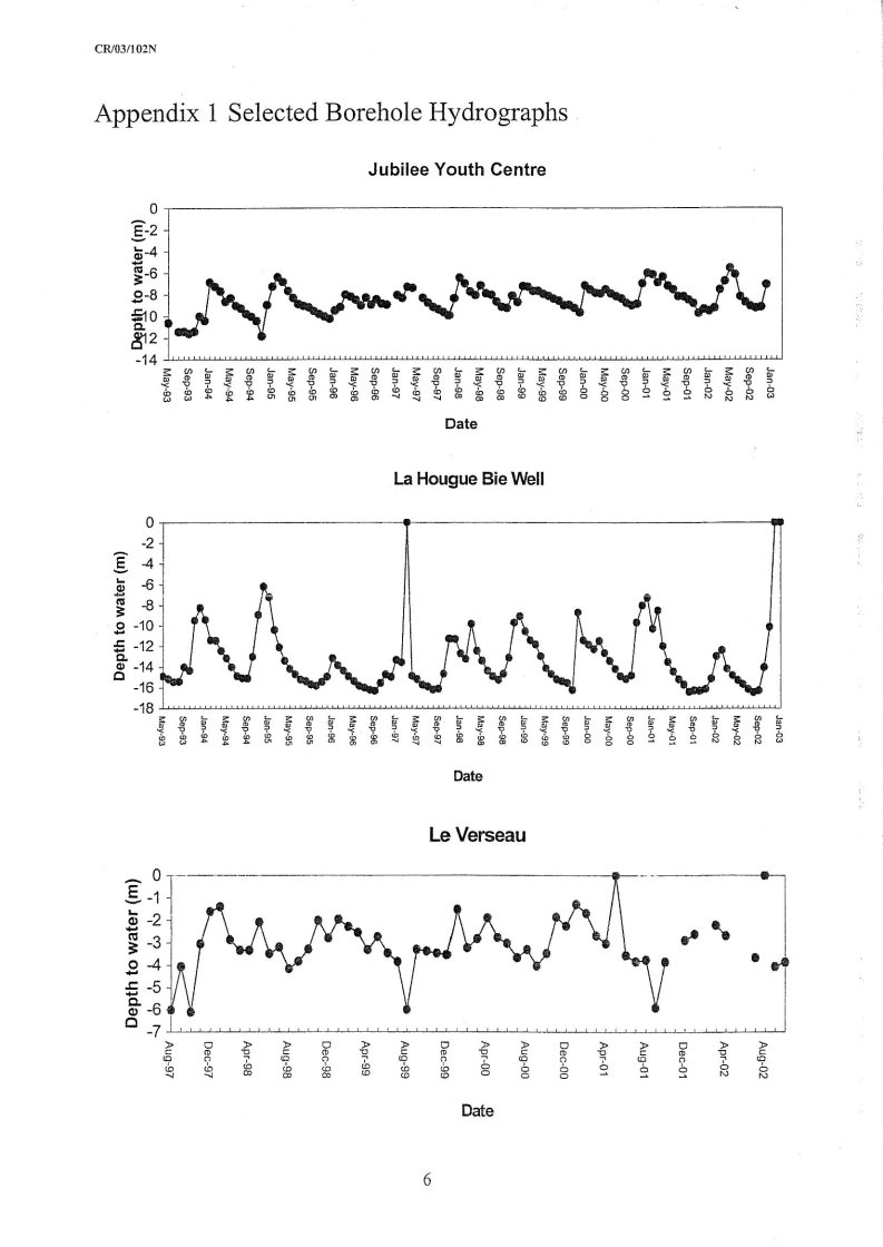
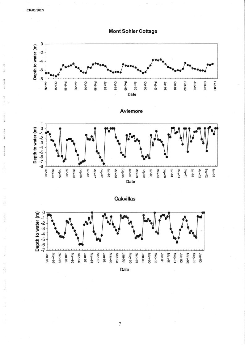
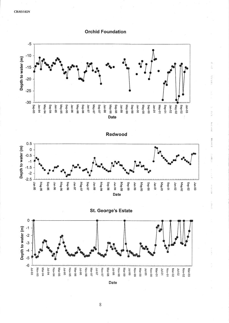
Appendix 1 provides copies of long term groundwater hydrographs for 9 wells provided in the most recent BGS annual report (CR/03/102N, Report for 2002). Details of well construction and location are not provided so detailed comment is not feasible. However, it is known that 1995/97 was a particularly dry period (The BGS report for April 1995 to March 1996 is sub- titled An exceptionally dry year') and annual rainfalls were low through 1995, 1996 and up to the beginning of winter of 1997/98. During this period actual rainfall was 20% to 25% below the average of 844 mm and infiltration may have fallen to 25 mm/year or less. (Table 3 - BGS Report RR/98/5)
The groundwater hydrographs show a natural annual fluctuation of 3 to 6 m with a generally falling groundwater level from February to October and a sharp increase in November to January. Absolute levels are not reported but depths appear to be principally in the range 0- 10 m below ground level with an annual range of fluctuation of 2-8 m. Minimum levels reported are for winters 1996/7. These are an average 0.5 m lower than general annual minimum levels. This represents an additional reduction in groundwater levels of 10-15% resulting from a possible 80% below average annual recharge.
There is no long term trend of declining groundwater levels apparent from the data presented by BGS, nor is there any indication of significant depletion of groundwater resources in the dry years of 1995/96.
No evidence is presented of the relationship between groundwater levels and stream baseflows throughout this period.
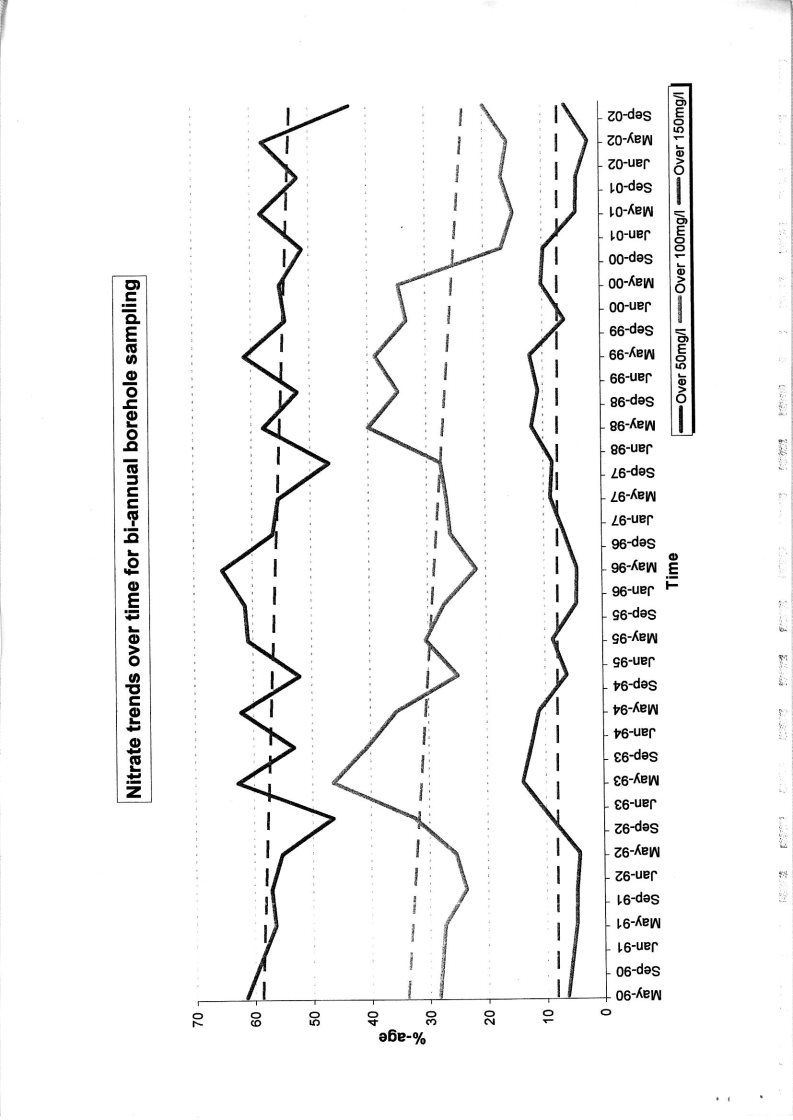
Overall, groundwater chemistry is consistent throughout the 12 year measurement period. Nitrate levels have been falling gradually since 1990, (see Appendix 1, reproduced from BGS report for 2002 (CR/03/102N) probably as a result of improved agricultural practice. Organic contamination (using Chlorthal as an indicator) appears to have peaked in 2000/01 and by 2002 reduced to pre 2000 levels'(CR/03/102N) although locally high concentrations remain of concern.
Isotope studies demonstrate that the bulk of the nitrate originates from fertiliser application, suggesting that natural recharge is significantly greater than soakaway seepage. Also the results of Tritium analysis are interpreted to suggest that the bulk of the groundwater is less than 30 years old. (Atmospheric testing of nuclear weapons which ceased in the 1960s is the principal source of tritium in natural waters)
Other conclusions based on chemical data are:
- Intrusion of sea water into the aquifer is localised to the southeast area of the island, perhaps 1 to 2% seawater in groundwater (the St Ouen's sand aquifer is protected from seawater intrusion by its shape and elevation);
 Some older (deep circulation) groundwater may be present in the granites of the southeastern part of the island.
No data is presented on surface water quality. Of particular relevance would be river/stream water quality at low flow condition when the bulk of surface water flow is likely to be sustained by groundwater fed seepage.![]()
|
|
|
| (Reproduced from BGS Description of 1:25,000 Channel
Draft Water Resources (Jersey) Law TechnicalAssessment of Evidence Presented Figure 2.1a Geological Structure of Jersey June 2004 13668-S01.cdr wrigs02 |
|
| C04/007-CCSL British Geological Survey ' NERC.All rights reserved. |
|

|
|
| ||
|
| Key
Holocene
Pleistocene
(Reproduced from BGS Description of 1:25,000 Channel Islands Sheet 2, HMSO, 1989) |
| |
Scrutiny Review Draft Water Resources (Jersey) Law TechnicalAssessment of Evidence Presented Figure 2.1b Drift Deposits of Jersey | ||||
June 2004 13668-S02.cdr wrigs02 |
| |||
| C04/007-CCSL British Geological Survey ' NERC.All rights reserved. |
| ||
|
|
| ||
| (Reproduced from Hydrogeological Map of Jersey, BGS
Draft Water Resources (Jersey) Law TechnicalAssessment of Evidence Presented Figure 2.2 BGS Conceptual Understanding of Jersey Groundwater June 2004 13668-S03.cdr wrigs02 |
| ||
| C04/007-CCSL British Geological Survey ' NERC.All rights reserved. |
| ||


Virtually all technical questioning of the BGS appraisal of the groundwater resources originate from WDEA. These questions derive from the conviction that the BGS conceptual understanding is incorrect. This is based principally on: • The view that the geology of Jersey is complex and that the concept of groundwater resources as a single water body supported by topographically driven north-south flow is not totally compatible with the overall geological structure (see Figure 2.1), divining experience or observation; • The conviction that there is deep movement of groundwater sustained by flow from the French mainland (Cherbourg Peninsula) 25 km to the east. Consequently the model of Jersey groundwater as a shallow reservoir is rejected. To support this view, evidence is presented of: • 50 boreholes deeper than 40 m, where water was encountered at depth and under pressure and which provide yields in the 10-500m³/day range; • Substantive east-west flow of groundwater from observation and divination. It is also stated that there is no local knowledge to support the repeated BGS reference to wells failing' because of seawater intrusion or falling groundwater levels. A WDEA commissioned report (Water Resource Review of Jersey, Environmental Management Consultants, January 2001) confirms the over simplification of the BGS model and concludes that "currently there is no evidence of stress on the groundwater resources of the island", although this is qualified by the statement that "it is not possible to state with any degree of certainty that there is a surplus of groundwater resources which is adequate to meet the effects of any prolonged period of reduced recharge". A number of organisations other than WDEA have expressed opinions opposing the draft Water Resources Law. These are predominantly related to administrative costs and difficulties, legal implications, infringements of individual rights, impact on tourism and agriculture and increased bureaucracy. Support for the proposed Law is expressed by Concern on the basis that resource protection, particularly in the context of climate change, is for the benefit of all and discharges our responsibility to future generations. The Jersey New Waterworks Company support is based on their agreement that the groundwater resources of the island are shallow and vulnerable particularly in the context of high population densities and climate change predictions. The submission reiterates the |
recommendation for immediate legislation to protect and safeguard water resources of the 1992 Working Party on Water Resources. This 1992 report was based on the full acceptance of the analyses and conclusions of the BGS Report WE/91/15 (Hydrogeological and hydrogeochemical survey of Jersey) and concludes that We are persuaded that the groundwater resources are being depleted faster than they are being replenished'. And that definition of the severity of the problem will require monitoring for at least 3 consecutive years'.![]()
The onset of global warming is accepted as a reality by most informed scientific and technical opinion. The impact on future climatic patterns and rainfall is less certain and a number of scenarios have been developed and modelled dependent on the sustained rate of greenhouse gas emissions. The overall interpretation is that the most likely water resources impact for the Channel Islands will be a close to 10% increase in winter rainfall and a 10-15% reduction in summer rainfall by the 2020s. However as temperatures increase actual evaporation also increases and overall "effective" rainfall is reduced. The impact of this potential change on the groundwater recharge in Jersey has not been analysed. A potential reduction in recharge of up to 10% has been determined for other parts of the United Kingdom. |
Since 1996 the BGS appear to recognise that, with the possible exception of extremely dry years, the groundwater resources of Jersey give no indication of stress. Groundwater levels have not declined, levels of nitrate contamination have in general terms, been declining since 1990 and there is no indication of stress even in the exceptionally dry year of 1996. The emphasis of the purpose of abstraction licencing has shifted from the protection of a resource under severe threat to the acquisition of an accurate view of overall abstraction rates and patterns for long term strategic planning purposes. The BGS review is based on a simplified conceptual model of the hydrogeology of Jersey but although simplified it is an extremely conservative or cautious model. Anthropogenic inputs to water resources are minimised, possible deep groundwater flow is ignored and no reference is made to reported large groundwater inflows during underground construction activities in St. Hellier. All of these factors could further increase the estimates of resource available. Measurement of abstraction is poorly constrained. The most recent estimate of 3.6 Mm³/year excludes public supply which Jersey New Water Works Company reports (Environmental Management Consultancy, 2001) indicate are generally 0.2 - 0.3 Mm³/year but increased to 0.45 Mm³/year in the dry year of 1996. Current recharge estimates are of the order of 15-17 Mm³/year This law proposes the establishment of a Regulator to licence abstraction of ground or surface water at rates greater than 3m³ in 24 hours. The only exception being shared domestic supply where the limit is set at 3 m in 24 hours per household. Domestic supply sources will be required to be registered. The power to restrict abstraction under drought conditions is also vested in the Regulator. Regulations indicating the means by which licence determination will be made are not prescribed. At present in England and Wales, applications to abstract groundwater are determined by the environment Agency in the context of natural or benchmark' river flow-duration' curves, ecological sensitivity and hydrogeological analysis interpreting the likely impact of groundwater abstractions on the baseflows and wetlands within the particular catchment. Abstractions below 20 m³/day do not require licensing. As the introduction of the Water Framework Directive evolves, the process of abstraction application determination is unlikely to change significantly. It may evolve to take a more rounded view of the hydro-morphological elements influencing ecological status, and to identify and enhance protection for pristine' headwaters. The general target is to ensure that ecology is |
maintained at (or restored to) the equivalent of Good Status' as identified by a nationwide monitoring network.
Maintaining ecological integrity is a key principal of both the present and anticipated licensing regimes and groundwater provides important support to surface water bodies and terrestrial ecosystems, particularly in summer periods.
In both the present and anticipated licencing regime, the control measure is the status of the ecology maintained by the volume and quality of surface water flows which, particularly in summer periods, are supported by groundwater.![]()
There appears to be little merit in entering into technical discussion of resource estimates in the course of the Scrutiny hearings. All data and comment now confirms that there is little or no visible evidence of resource stress' and certainly not of collapse of the resource. This view is based on the essentially conservative' conceptual model proposed by BGS. The identification of further deep groundwater resources or recharge from mains and soakaways would provide further insurance but would not alter the established principle. The stated purpose of the proposed legislation is for the better management and enhancement of water resources in Jersey, the fauna and flora that are dependent on inland waters and their habitats, and the natural beauty of the island' (Draft 12, 27 April 2004, P3). The BGS Report IR/01/26 (Report for the Year 2000) discusses the case for groundwater abstraction licensing based on the premise that The analysis of the water cycle for Jersey remains incomplete without measurement of source abstraction volumes.' Threshold values for license requirements are discussed and it is concluded that the requirement should be for licensing of abstraction for all purposes other than domestic'. This report is not written from a perspective which permits comment on the legal principal of abstraction licensing in the context of the traditions of the island of Jersey. The suggested approach is to investigate the basis for the proposed legislation and the regulatory means by which it might be implemented. Some suggested queries are: • Is complex and potentially punitive legislation the correct means of initiating a programme of measurement of resource use? • Is there sufficient understanding to justify the treatment of the whole of the island as a single catchment unit? • What is the regulatory principle and mechanism by which applications to abstract will be determined? • Is the relationship between river and wetland ecological status' understood and documented? • Why has there been no publicised retraction or amendment of the pre-1996 published view of extreme resource stress and imminent collapse? |
![]() Appendix A
Appendix A
Borehole Hydrographs and Nitrate Trends
[Reproduced from Jersey Groundwater 2002' (BGS Report CR/03/102N)]
![]()
![]() 4 Pages
4 Pages
![]()